Farewell V-City, welcome VirtualGeo, CityEngine and iLight products
After three fabulous years of collaborative research efforts, technological challenges, successes and friendship, the V-City consortium has announced the termination of the V-City project, an amazingly successful research European project.
Our dear project has generated world-class products that are now commercially available worldwide:
VirtualGeo (aka the V-City Explorer) is now a widely adopted flagship product of the DIGINEXT company with more than 120 000 users in November 2012.
CityEngine (aka the V-City Builder) has been acquired by ESRI and is following the same successful road.
iLight (aka the V-City Table) sold by Immersion is the first, and still the best, multi-user multitouch stereo table available on the market.
We would have loved to continue the research adventure started end of 2008 with the precious and indispensable support of the European Commission. There is so much more we could do! But life is life and EC projects are EC projects. Good or bad they all end the same way and all depend on the EC priorities and supported topics ...
DEC 5-6 2011
V-City honoured by the European Commission, Innovation Convention 2011, 5-6 Dec. 2011, Brussels
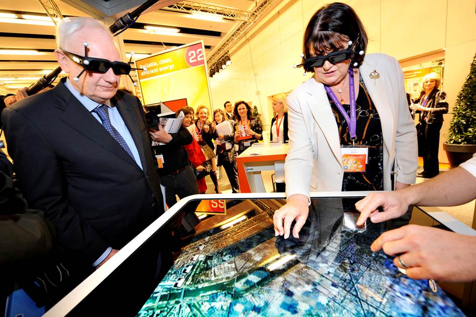
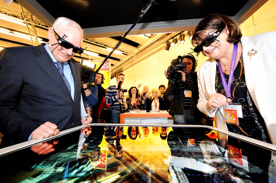
The V-City Project has been selected with 49 other European FP7 research projects for the Innovation Convention 2011 organised by the European Commission on both the 5th and 6th of December 2011. The latest project results have been demonstrated on the V-City booth where hundreds of enthousiatic attendees have been invited to test and evaluate the V-City systems.
More information is available at Innovation Convention 2011 website.
This first edition of the Innovation Convention has been opened by President Barroso one year after the adoption of the Innovation Union flagship initiative, the EU's roadmap to turn Europe into a more innovation-friendly and competitive continent.
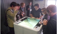
The V-City booth
European Commissionner Maire Geoghegan-Quinn, and Philippe Maystadt, the President of the European Investment Bank, discovering and experiencing the V-City table. Source European Commission Press
NOV 24 2011
V-City technology presented at GeoWorld Expo 2011, 24 Nov. 2011, Paris
The VirtualGeo SDK, which integrates the V-City Explorer technology and is integrated in the brand new GeoConcept V7 flagship product, will be presented by GeoConcept at GeoWorld 2011. More information is available here.
AUG 26 2011
New scientific papers available
The V-City consortium has just released a scientific paper recently presented in Advanced Concepts for Intelligent Vision Systems (ACIVS 2011).
This paper is available online in the Downloads section of this site.
AUG 09 2011
V-City presented at SIGGRAPH 2011 - Vancouver, Canada, August 9 2011
Pascal Müller, from Procedural, has presented the V-City project in his course on "Procedural Urban Modelling in the Industry" at SIGGRAPH 2011. This course, which is available in the download section, is part of the "Modeling 3D Urban Spaces Using Procedural and Simulation-Based Techniques " session with co-instructors Peter Wonka from Arizona State University, Daniel Aliaga and Carlos Vanegas from Purdue University, and Michael Frederickson from Pixar Animation Studios. The course covered urban layout design, road modeling, and computational building design as well as a discussion of how CityEngine was used in the Disney/Pixar movie, Cars 2.
In addition to this course, CityEngine has been demonstrated at 3DConnexion's booth #970 where visitors got an exclusive preview of the upcoming CityEngine 2011, which integrates the V-City Builder technology.
AUG 08 2011
V-City makes millions of kids (and parents) enjoy unprecedented urban backgrounds in Cars2 movie
Disney/Pixar's animated feature sends the star race car Lightning McQueen around the globe to race in the World Grand Prix. The showplace sets are the cities with the main race tracks. As for covering all that ground with more than 120 original sets, Pixar tried to use a more procedural approach. "Or at least get the city blocked in, and then you can work in the detail for the foreground or the landmarks," says Apurva Shah, supervising technical director. "So we used CityEngine" that integrates the V-City Builder technology.
Get more information on Procedural's website
To get exclusive insights about Pixar's procedural modeling approach in Cars 2, join the SIGGRAPH 2011 course 'Modeling 3D Urban Spaces Using Procedural and Simulation-Based Techniques'.
AUG 03 2011
V-City Workshop #3 at VAST 2011 - Prato, Italy, October 18-21 2011
The V-City consortium will welcome you at the VAST 12th International Symposium on Virtual Reality, Archaeology and Cultural Heritage that will take place from the 18th to the 21st of October in Prato, Italy. The conference attendees will be invited to participate in the validation sessions of the V-City final release that will take place on the booth. More to come in the next weeks ...
JUL 11 2011
Breaking News (again): The V-City consortium welcomes Esri!
We are very excited to announce that Procedural, a V-City consortium member, has joined forces with Esri, the global leader in geographic information systems (GIS)!
Today, Esri president Jack Dangermond announced the acquisition of Procedural in front of thousands of attendees at the Esri International User Conference in San Diego.
CityEngine, which includes the V-City Builder technology, will continue to evolve and expand as a stand-alone product, and many of the innovations developed in the frame of the V-City project at Procedural will be brought to Esri’s leading GIS solution of ArcGIS. Thus, CityEngine technology will extend its reach by several orders of magnitude, touching thousands of city administrations and GIS professionals
About ESRI
The Californian company is the market leader in geographic information systems (GIS) and one of the world’s largest privately-held software companies.
Esri uses the name ArcGIS to refer to its suite of GIS software products, which operate on desktop, server, and mobile platforms. ArcGIS also includes developer products and web services.
JUL 04 2011
Breaking News: the V-City technology selected for the next French GeoPortail!
We are very proud to announce that DIGINEXT's VirtualGeo3 system, which integrates the V-City Explorer technology, has been selected to be the 3D browser of the next generation French GeoPortail, which will comply to the INSPIRE directive. This project will be carried out by a consortium of companies led by Atos Wordline with the ambition to release the new GeoPortail V3 mid-2012.
Géoportail is the geographic portal of the French government whose aim is to publicise georeferenced data about the whole French territory. This service, developed by two public agencies (the IGN and the BRGM), was officially inaugurated on June 23, 2006. With millions of connections, this massively successful service originated for two main purposes:
to comply with the INSPIRE (Infrastructure for spatial information in Europe) European directive and ADELE French programme aim at the development of on-line administrative information;
to provide a national alternative to other online projects such as Google Maps and Google Earth
About IGN
The Institut Géographique National is the French national provider of reference geographic information, heir to the French Armed Forces Geographic Department (Service Géographique des Armées – SGA) founded in 1887. Its role is to describe, from a geometric and physical perspective, the surface and land use of the national territory, to make all appropriate representations thereof and to distribute this information. Initially a map designer, today, IGN produces increasingly exhaustive digital databases, that can be used for many applications. It thereby contributes to development planning, sustainable development and environmental protection, national defence, civil security and risk prevention, as well as to the promotion and standardisation of national and international applications of geographic information.
About Atos Worldline
AtoS Worldline brings together AtoS' core expertise in Hi-Tech transactional services. A leader in end-to-end services for critical electronic transactions, AtoS Worldline is specialised in electronic payment services (issuing, acquiring, terminals, card and non card payment solutions & processing), eCS (eServices for customers, citizens and communities) as well as services for financial markets. Atos Worldline on-going commitments to research and innovation enable its customers to benefit from award-winning solutions in areas such as mobile payments, secure IPTV, online CRM and paperless solutions. Atos Worldline generates annual revenues of € 867 million and employs over 5,400 people in the world among the 75 000+ employees of the AtoS group..
JUL 02 2011
V-City project presented at INSPIRE 2011 - Edinburgh
The V-City consortium will welcome you at the INSPIRE conference from June 27 to July 1 2011. The project will be presented during poster sessions and demonstrated in the exhibit area (location to come). The conference attendees will be invited to participate in the validation sessions of the V-City final release that will take place on the booth.
INSPIRE is setting up the framework for a spatial data infrastructure for the purposes of European Community environmental policies and policies or activities which may have an impact on the environment. More information on the conference is available on the INSPIRE website.
MAR 23 2011
New scientific papers available
The V-City consortium has just released two scientific papers recently presented in both the 4th international workshop on 3D Virtual Reconstruction and Visualization of Complex Architectures (3D-ARCH'2011) and (3DIMPVT 2011).
Both these papers are available online in the Downloads section of this site.
MAR 18 2011
Breaking news: the V-City technology selected by GeoConcept for its future product line
We are very happy to announce that, after several months of evaluation, GeoConcept, the leading European Geographic Information system editor, has selected the V-City technology, namely the V-City Software Developer Kit (VrGIS) and the V-City Explorer (branded as VirtualGeo3) as the 3D cartographic engine at the heart of its future flagship product GeoConcept 7. Click here for more information.
About GeoConcept SA
First leading European editor of Geographical Information Systems, GeoConcept SA is one of the main world providers of cartographical optimization technologies for professionals. GeoConcept, an avant-gardist company, is the unique "conceptor" of innovative solutions aiming at deeply improving the efficiency of companies and organizations. By combining geographical information and optimization tools, GeoConcept invented "geoptimization", that is to say business optimization through the intelligent integration of geographical information into the systems. Benefits from geoptimization can apply to various fields such as tourism, geomarketing, territory management, crisis management, mobile forces management...
FEB 01-03 2011
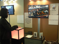
The V-City project presented at Imagina 2011 - Monaco
The V-City beta release, along with the V-City multitouch stereoscopic table, has been presented at the Imagina conference on DIGINEXT
booth. As usual, our booth welcomed a large number of visitors including a team of Euronews who interviewed our V-City team. The footage has been broadcasted during Euronews journal. Click here for more.
NOV 10 2010
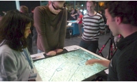
The V-City project selected and presented at ACM International Conference on Interactive Tabletops and Surfaces 2010 - Saarbrücken, Germany.
We are happy to announce that the V-City results have been selected and presented at the ACM ITS 2010 conference. Our demos have attracted an incredible number of visitors, and the map table principle, mixing tactile and stereo head tracking, has been received as a major innovation. The V-City results have been considered as some of the most exciting ones in the exhibition.
SEP 10 2010
Website update
Following the huge success of the V-City SIGGRAPH presentation and the large press coverage, we are happy to open a new section of the website compiling all the articles we found about the V-City project. You can consult them in the Download section or [here].
We thank you in advance for informing us (vcity@diginext.fr) about any article we may have missed.
We are also happy to release a new version of both the V-City poster and brochure that can be downloaded from this site. Feel free to contact us in case you need a high resolution version.
JUL 25-29 2010
V-City presentations at SIGGRAPH 2010, Los Angeles Convention Center - United States
The V-City consortium is pleased to announce that its two submissions to the SIGGRAPH 2010 have been accepted. Representatives of the consortium will present the project results on the Emerging Technologies area and give a talk about the V-City technology.
The V-City system will be demonstrated at the Emergining Technologies sessions. This demonstration merges intuitive 2D collaboration with 3D display techniques such as viewpoint tracking and stereoscopic rendering. While efficient hardware systems and software algorithms have been well-identified for each technology, combining them raises totally new issues. For instance, each stereo viewing angle is unique, stereo rendering is usually single-viewpoint only, and the focal plane and stereo parameters must be precisely controlled to avoid collision between fingers and virtual objects. In 3D Multitouch's application to city planning, two users share interactions in the 3D city, but each has a unique view of the content, just like they would on a real mockup. Additionally, the system controls stereo parallax by detecting the users' hands and fingers, which allows the most immersive negative parallax when no arm occludes the content. The system switches to positive parallax when users are closer. This unique two-user, stereoscopic multitouch system focuses on the issues and constraints that will most certainly motivate such research work in the future. The goal of the demonstration is to let attendees experience the system and the new problems it introduces, and discuss its preliminary solutions.
The V-City system will also be presented at the Touchy-Feely talk, Thursday, 29 July | 3:45 PM - 5:15 PM | Theater 411,
Session Chair: Dylan Moore, Apple Computer, Inc.
JUL 24-25 2010
V-City paper presented at the ACM Web3D conference, Los Angeles Convention Center - United States
The V-City consortium is happy to announce that its scientific paper submited to the 15th ACM conference on 3D Web Technology has been accepted. It will be presented on Sunday, July 25 at 14:00. The ACM International Web3D 2010 Conference will be co-located to ACM SIGGRAPH 2010 (http://www.siggraph.org/s2010/) at the Los Angeles Convention Center.
JUN 11-15 2010
V-City presented at Eurosatory 2010, Paris, France
The V-City Explorer has been demonstrated on Immersion's booth during the Eurosatory 2010 exhibition in Paris. The Explorer displayed a stereoscopic view of the urban environments control with Immersion's cubtile first ever 3D multitouch device. From June 14th to 18th 2010, Eurosatory not only confirmed but also built on its role as the world-leading land, airland and homeland defence exhibition. It was attended by 1,330 exhibitors from 52 countries and drew 52,414 visitors from 131 different countries.
Second V-City Workshop in Ausonius Institute, Bordeaux - France
The V-City consortium organised the second V-City Workshop in the Ausonius Institute, Bordeaux - France, on the 8th of June 2010.
The programme of this workshop dedicated to the reconstruction and interactive visualisation of massive urban 3D environments is available here. Attendees had the opportunity to test the V-City result and exchange with the researchers of the project.
The Ausonius Institute is a Mixed Research Unit (UMR 5607) of CNRS and Bordeaux 3 University created in 1996. It is specialised in the fields of archaeology, antiquity and the Middle Ages, and has become a leader in creating virtual reality models of “lost objects”, like the Circus Maximus of Rome used in the famous Rome Reborn project. The Ausonius Institute hosts the 3D Framework Lab hat is in charge of the research on the use of 3D technologies in the fields of Cultural Heritage and Archaeology.
It is today operating the “Conservatoire National des données 3D du patrimoine”, with a national mission for the storage and preservation of the French 3D data related to cultural heritage.
FEB 18 2010
Procedural Wins Global Top 100 Companies Award
Procedural, a member of the V-City consortium, announced today that it has been selected as a Winner for Red Herring's Global 100 award, a prestigious list honoring the year’s most promising private technology ventures from around the world.
Red Herring’s Global 100 list has become a mark of distinction for identifying promising new companies and entrepreneurs. Red Herring editors were among the first to recognize that companies such as Google, Yahoo, Skype, Netscape, Salesforce.com, YouTube, and eBay would change the way we live and work.
“Choosing the best out of the previous three years was by no means a small feat,” said Alex Vieux, publisher and CEO of Red Herring. “After rigorous contemplation and discussion, we narrowed down our list from 1,200 potential companies to 200 finalists. Trying to get it down to 100 companies was a task upon itself. The top 100 companies who were chosen should be extremely proud, the competition was difficult.”
Red Herring’s editorial staff evaluated the companies on both quantitative and qualitative criteria, such as financial performance, technology innovation, management quality, strategy, and market penetration. This assessment of potential is complemented by a review of the track record and standing of start-ups relative to their sector peers, allowing Red Herring to see past the “buzz” and make the list an invaluable instrument of discovery and advocacy for the greatest business opportunities from around the world.
FEB 10 2010
Geographic Web Portals Seminar, CCT-TSI, Toulouse - France
DIGINEXT has presented the V-City project in the "Geographic web portals" seminar organised by the French Space Agency and the CCT Technical Competence Centers. The V-City project was officially announced before the Google Earth presentation of E. Parsons, Google Geospatial Technologist.
The objective of this event was to overview the latest achivements and perspectives of the 3D Geographic information field of applications. Some
Geographic web portals have been presented, and also some nice Open
Source applications where the 3D components are taken into account.
JAN 01 2010
Season's greetings and the consortium life
The V-City consortium wishes you a wonderful New Year 2010!
We are also happy to announce the spin-off of CS' Virtual Reality Department to CS 100% owned DIGINEXT company. DIGINEXT will represent the CS Group in the V-City consortium.
 The V-City Project has been selected with 49 other European FP7 research projects for the Innovation Convention 2011 organised by the European Commission on both the 5th and 6th of December 2011. The latest project results have been demonstrated on the V-City booth where hundreds of enthousiatic attendees have been invited to test and evaluate the V-City systems.
More information is available at
The V-City Project has been selected with 49 other European FP7 research projects for the Innovation Convention 2011 organised by the European Commission on both the 5th and 6th of December 2011. The latest project results have been demonstrated on the V-City booth where hundreds of enthousiatic attendees have been invited to test and evaluate the V-City systems.
More information is available at 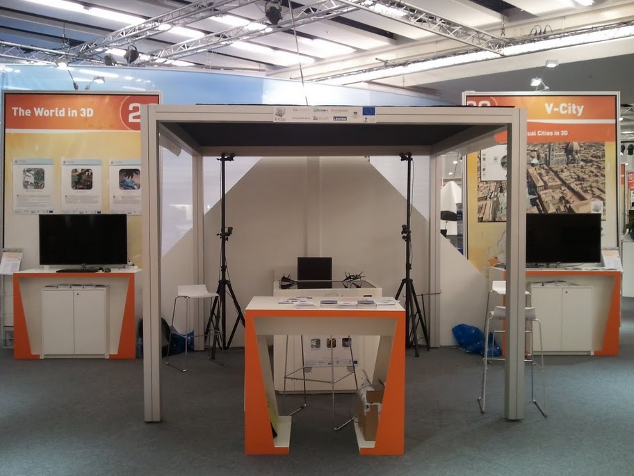
 The VirtualGeo SDK, which integrates the V-City Explorer technology and is integrated in the brand new GeoConcept V7 flagship product, will be presented by GeoConcept at GeoWorld 2011. More information is available
  Pascal Müller, from Procedural, has presented the V-City project in his course on "
 Disney/Pixar's animated feature sends the star race car Lightning McQueen around the globe to race in the World Grand Prix. The showplace sets are the cities with the main race tracks. As for covering all that ground with more than 120 original sets, Pixar tried to use a more procedural approach. "Or at least get the city blocked in, and then you can work in the detail for the foreground or the landmarks," says Apurva Shah, supervising technical director. "So we used CityEngine" that integrates the V-City Builder technology.
Get more information on
Disney/Pixar's animated feature sends the star race car Lightning McQueen around the globe to race in the World Grand Prix. The showplace sets are the cities with the main race tracks. As for covering all that ground with more than 120 original sets, Pixar tried to use a more procedural approach. "Or at least get the city blocked in, and then you can work in the detail for the foreground or the landmarks," says Apurva Shah, supervising technical director. "So we used CityEngine" that integrates the V-City Builder technology.
Get more information on  We are very excited to announce that Procedural, a V-City consortium member, has joined forces with
  We are very proud to announce that DIGINEXT's VirtualGeo3 system, which integrates the V-City Explorer technology, has been selected to be the 3D browser of the next generation French
  We are very happy to announce that, after several months of evaluation,

 The V-City consortium organised the second V-City Workshop in the
  Procedural, a member of the V-City consortium, announced today that it has been selected as a Winner for Red Herring's Global 100 award, a prestigious list honoring the year’s most promising private technology ventures from around the world.
 DIGINEXT has presented the V-City project in the